| RNW - 388kHz - Chocowinity, NC |
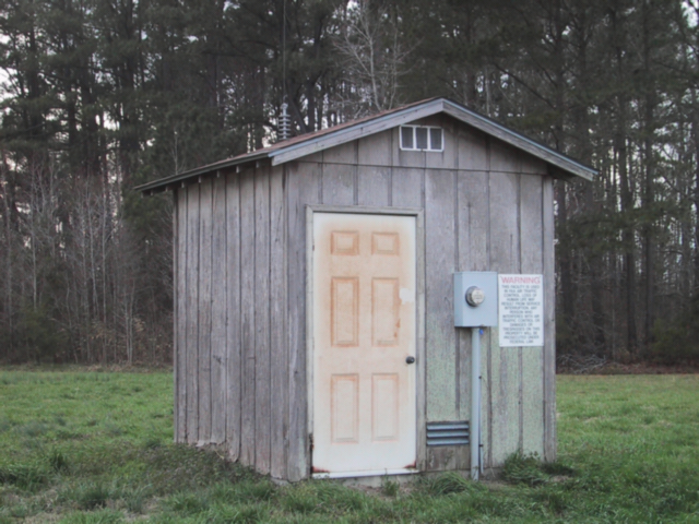
RNW - this is a *Real* NDB hut.
As classic a rural NDB as it gets. Two thirty-foot poles some 150 feet apart, centre-fed vertically from the transmitter hut directly underneath. At 25 Watts, with this antenna, and presumably with the space available a decent ground system, RNW gets out reasonably well; despite copious co-channel signals I can hear it quite often at home in Pennsylvania, some 400 miles distant. The 1020Hz keying is a bit wonky, but distinctive as a result.
Chocowinity is a small crossroads town just across the Pamlico River, south of Washington on the way to New Bern, NC. (It is just a few miles from the massive 'Greenville' VOA 'B' shortwave broadcast site, but that's a whole other story.) I'd prepared for finding the site by gleefully marking on a topographic map the lat/long of the beacon as given in a database, thinking all would be easy. Oho . . . The plot had me looking around the grounds of the town's Middle School, the sports areas of which had DOZENS of phone poles and other such-like things as lighting standards, all linked with cables. It took me half-an-hour and much glaring-at by custodians and staff to convince myself there was no NDB hiding there. At the same time, RNW was blocking the radio, so it WAS close; the sheer strength and all the wires in the air was making getting a DF bearing impossible.
Yet another case of mis-direction or erroneous data - the lat/long data was obviously wrong. So, I drove out half-a-mile or so on each of the four 'spokes' from the town cross-roads and took DF bearings; these seemed to indicate the beacon was indeed close to where I had been, but probably a bit to the west. A bit of radio-out-the-car-window DFing closer in had me looking at a bunch of trees and hedgerow across some fields. Needed the exercise; sure enough, substantially hidden behind the hedgerows was The Hut, the poles disguised perfectly by surrounding trees. The site itself is a few hundred feet across the fields across the road from the Middle School, up a barely used farm track; the lat/long was out by perhaps 1/4 mile. Nowadays, of course, driving by I can see the sticks immediately, now I know where to look . . .
Some other pictures:
© Steve Dove, W3EEE, 2003,4